Central Valley Project: Bureau of Reclamation Reports on San Luis Unit, Auburn Dam, Corps of Engineers, Delta Division, Friant Division, Sacramento River Division, Shasta Division, Trinity Division
Nonfiction, Science & Nature, Technology, Engineering, Civil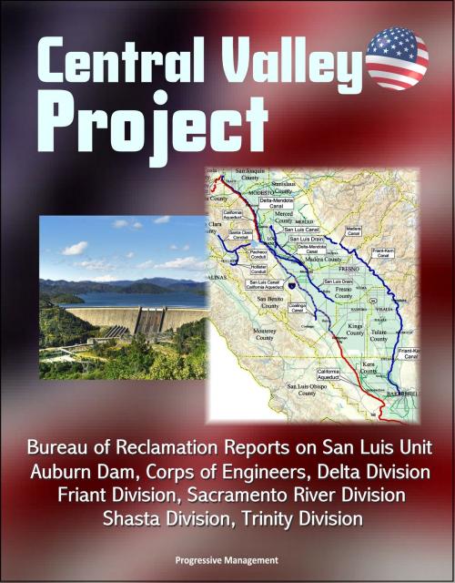
| Author: | Progressive Management | ISBN: | 9781310328114 |
| Publisher: | Progressive Management | Publication: | October 10, 2014 |
| Imprint: | Smashwords Edition | Language: | English |
| Author: | Progressive Management |
| ISBN: | 9781310328114 |
| Publisher: | Progressive Management |
| Publication: | October 10, 2014 |
| Imprint: | Smashwords Edition |
| Language: | English |
Nine official project documents provide unique insights into the Central Valley Project of California. California`s Central Valley Basin includes two major watersheds--the Sacramento River on the north and the San Joaquin River on the south--plus the Tulare Lake Basin. The combined watersheds extend nearly 500 miles from northwest to southeast and range from about 60 to 100 miles wide.
The basin is surrounded by mountains, except for a gap in its western edge, at the Carquinez Straits. The valley floor occupies about one-third of the basin; the other two-thirds is mountainous. The Cascade Range and Sierra Nevada Mountains, on the north and the east, rise to about 14,000 feet, and the Coast Range, on the west, rises to 8,000 feet. The San Joaquin River runs northward and most of its tributaries generally run east and west. These two river systems join at the Sacramento-San Joaquin Delta and flow through Suisun Bay and Carquinez Straits, into San Francisco Bay, and out the Golden Gate to the Pacific Ocean.
The Central Valley Project, one of the Nation`s major water conservation developments, extends from the Cascade Range in the north to the semi-arid but fertile plains along the Kern River in the south. Initial features of the project were built primarily to protect the Central Valley from crippling water shortages and menacing floods, but the CVP also improves Sacramento River navigation, supplies domestic and industrial water, generates electric power, conserves fish and wildlife, creates opportunities for recreation, and enhances water quality. The CVP serves farms, homes, and industry in California`s Central Valley as well as major urban centers in the San Francisco Bay Area; it is also the primary source of water for much of California`s wetlands. In addition to delivering water for farms, homes, factories, and the environment, the CVP produces electric power and provides flood protection, navigation, recreation, and water quality benefits.
The CVP: Reaches some 400 miles, from the Cascade Mountains near Redding in the north to the Tehachapi Mountains near Bakersfield in the south. Consists of 20 dams and reservoirs, 11 powerplants, and 500 miles of major canals, as well as conduits, tunnels, and related facilities. Manages some 9 million acre-feet of water. Annually delivers about 7 million acre-feet of water for agricultural, urban, and wildlife use. Provides about 5 million acre-feet for farms -- enough to irrigate about 3 million acres, or approximately one-third of the agricultural land in California. Furnishes about 600,000 acre-feet for municipal and industrial use--enough to supply close to 1 million households with their water needs each year.